


Building information modeling, BIM for short, is an international construction and design process that is saving companies a lot of time and money, not only in the U.S. but around the world. For example, a Korean research team has developed a BIM-based digital collaboration platform that allows construction owners and engineers to collaborate with each other on digital design tasks.
From a conventional perspective, collaboration in the construction sector is often seen as merely sharing an integrated workspace. However, this approach comes with drawbacks associated with space rents, difficulties in properly managing collaborative information, and ambiguity in defining roles and responsibilities. These problems can be addressed by establishing an integrated digital work environment for collaboration.
Against this backdrop, the BIM Cluster Research Team of the Korea Institute of Civil Engineering and Building Technology (KICT), developed a cloud-based BIM collaboration platform aimed at digitalization of collaboration in order management and design tasks for the first time in Korea. The developed platform streamlines conventional order placement and design collaboration processes, reducing the time required by more than 30%. This platform integrates more than 20 BIM files to concurrently visualize, review, approve, submit, and manage them. Another key advantage is it allows for realtime collaboration, regardless of when or where you are, through a digitalized construction work environment, eliminating the need for printed documents.

The research team established an online environment for digital collaboration while developing its own cloud environment to ensure data security across public facilities. For services using overseas public clouds, it is possible to build a platform that complies with a customized cloud environment while ensuring data security.
Predefined unit functions for collaboration are made available as open sources through a collaboration tool development framework. These features allow anyone to develop the online collaboration tools they want, adding scalability to this approach. Additionally, the research team has implemented an integrated web-based visualization viewer, specifically designed to visualize various BIM data for review on a single screen, including various meetings; issue management; schedule management; BIM data review, approval, and management; BIM models; documents; drawings; and images. This viewer facilitates online collaboration among relevant stakeholders, enabling them to work together seamlessly.
The researchers have recently developed an online collaboration web service in the form of SaaS (software as a service). This open-source-based integrated viewer allows various documents, drawings, and models to be visualized and displayed on a single screen. All these functions empower multiple team members to collaboratively review BIM models and efficiently record and address relevant issues in realtime. Furthermore, when linked to commercial software packages and platforms (from Autodesk or Bentley, for example), this system also facilitates the seamless exchange and sharing of any BIM data created by engineers, demonstrating exceptional versatility and interoperability.

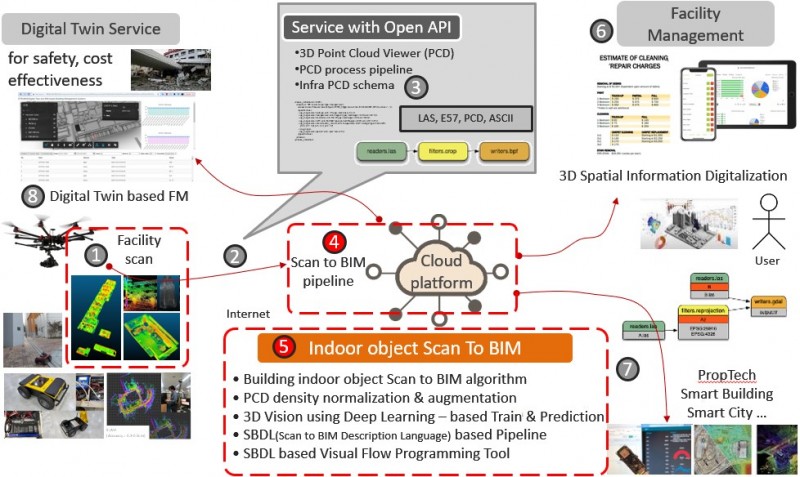
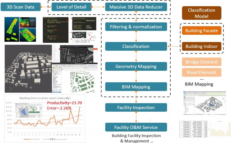
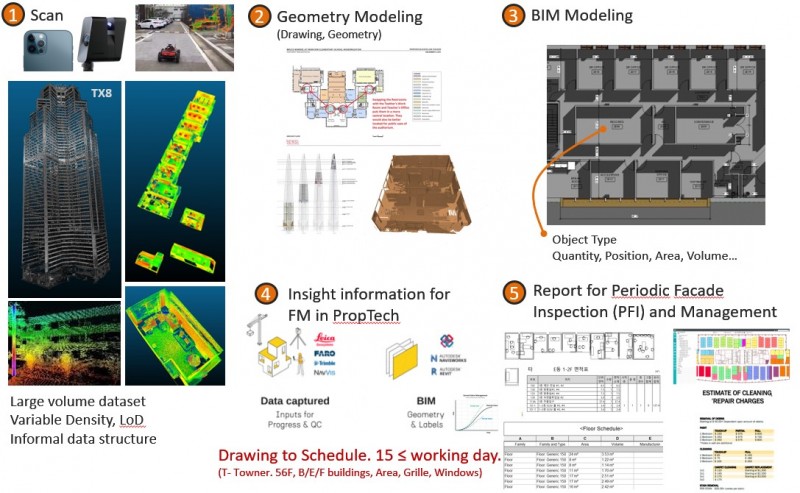
KICT has also developed a “building scan to BIM” reverse engineering technology that would be required for 3D geospatial information modeling domains such as digital twin information modeling. Scan to BIM-based reverse engineering technology was studied to prevent errors and rework caused by manual work when modeling shapes or BIM from 3D scan data.
Existing reverse engineering work is either done based on a lot of manual work or semi-automatically using expensive overseas software. This technology automatically segments objects from 3D point cloud data, extracts shape information, and creates BIM objects. Through this, information model creation time and rework required for digital twins can be dramatically reduced. In this regard, according to published data, this technology improves reverse engineering productivity by 23.7 times and improves the amount of modeling information by 110.21%. Additionally, this technology can be customized depending on the purpose.
This technology is used for 3D precision map construction, 3D vectorizing, abnormal pattern detection during construction site safety management, precise construction management, and 3D digitalization of spatial information using the location, size, and direction information of objects required from scanned image data, etc. It can be used as a base technology that can be used in vision-based robotics and autonomous driving support systems.

In a related project, KICT developed a digital model designed to identify dangerous roads where traffic accidents frequently occur while further finding optimal measures to improve the safety of such roads, thereby minimizing the risk of traffic accidents. This project aims to identify roads with a high risk of major traffic accidents and improve structural hazards found on them, preventing future traffic accidents, and enhancing their functionalities as well.
Under this project, dangerous roads are selected based on a combination of various factors, including their geometry, e.g., how the roads curve and slope, the number of traffic accidents, the amount of traffic, regional characteristics, and investment expenditures. Among them, however, geometry is the most significant factor in the scoring system. Simply put, the geometric structure of roads, which determines their overall shape, is considered among the major causes of traffic accidents.
The KICT BIM Research Cluster developed a digital design model to create an optimized linear road model capable of identifying dangerous roads and minimizing the risk of traffic accidents on them. The developed digital design model employs big data to ensure that dangerous roads are identified and selected in an objective manner, unlike the existing method in which the selection process is conducted in a fragmented manner.
The digital model developed by KICT was designed to quickly and easily provide multiple optimal alternatives to the selected road design in the form of a 3D model simply by inputting conditions and entering values for variables. In addition, it can also compare these alternatives in terms of the risk of traffic accidents and the volume of earthwork required, immediately determining whether each of these alternatives satisfies the design requirements. This process allows policymakers to determine which alternative will be the best solution to minimize the risk of traffic accidents.
The distinctive advantage of the developed technology is it integrates the entire process of decision-making, from the identification of dangerous roads to the generation of optimal alternatives using a digital model; that is, maximizing the efficiency of the process via digital transition.
Want to tweet about this article? Use hashtags #construction #sustainability #infrastructure #IoT