

The name LASER is an acronym for Light Amplification by the Stimulated Emission of Radiation. A laser device emits a beam of light through optical amplification. Spatial coherence keeps the beam within a narrow and tight path over long distances, allowing the energy produced to be used in applications as simple as a laser pointer or as concentrated as laser metal cutting.
Albert Einstein is credited with being the first to theorize about what makes lasers possible, stimulated emission. He detailed this theory in “On the Quantum Theory of Radiation.” Today, lasers are used in a wide range of technologies including optical disk drives, laser printers, barcode scanners, and the prior mentioned pointers and cutters—and welders. By adjusting the power, lasers are also used in critical surgery, particularly for the eyes.
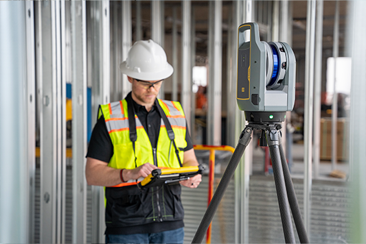
But those in the construction field might better know lasers from their application in surveying. The ubiquitous laser level and tripod can be found at the start of most jobs, collecting data on topography and interferences. A relatively new use is in scanning for reality capture, using that data for digital twin and BIM (building information modeling) work.
Take for example the popular Trimble 3D laser scanning system. The company recently introduced an advanced unit, the X9, to augment its X7 and X12 units. The Trimble X9 3D laser scanning system is built on Trimble’s laser scanning technologies, engineered to enhance performance in more environments while leveraging innovations such as Trimble X-Drive technology for automatic instrument calibration, survey-grade self-leveling, and laser pointer for georeferencing.

The new Trimble X9 expands on Trimble X7, but delivers longer range, higher accuracy, shorter scan times, and sensitivity, improving scan results and boosting productivity. Advanced processing and a high-performance laser increase the sensitivity of all scans. A new center unit design improves signal transmission for better scan quality. With more efficient reality capture capabilities, the X9 broadens potential applications for customers in surveying, building construction, oil and gas, rail, forensics, monitoring, tunneling, mining, and others.
The Trimble X9 allows safe and effective creation of as-built models for scan-to-BIM and renovations and provides clarity for adaptive reuse, building extensions, and inspection of facades and elevations. Also use it to:
- Optimize commercial building design accessibility.
- Produce high quality colorized point clouds to clearly view the project off-site.
- Register in the field to eliminate the risk of return visits, especially where access permits are difficult to obtain.
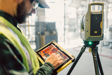
- Transfer data to Trimble Business Center, Trimble RealWorks, or other CAD (computer-aided design) software for final analysis and design.
With the Trimble X9, creation of as-built documentation for drawings or models for bridges, tunnels, dams, and other civil infrastructure is possible with a range that allows for operation from a safe distance. The area scan feature provides high-resolution data on areas of interest. It can also be used to:
- Incorporate scan information in clearance calculations, modeling, inspections, renovations, and expansion work.
- Leverage high-speed data capture and quickly capture area scans to reduce downtime for critical infrastructure projects.
- Benefit from HDR image quality for visual inspection and sharing of information.
- Register in the field to verify scan data is complete before importing to Trimble Business Center or Trimble RealWorks at the office.
The X9 provides time savings with accurate and dependable data, enabling confident decision making both in the field and in the office through in-field registration within Trimble Perspective and Trimble FieldLink by minimizing the need for target deployment. The auto-calibration eliminates the need for annual calibration, which lowers the cost of ownership, reduces downtime, and significantly increases the users’ return on investment. In addition, the X9 also includes survey-grade self-leveling.
Want to tweet about this article? Use hashtags #construction #infrastructure #IoT #cloud #edge