

With the passage of the Bipartisan Infrastructure Law, one of the largest and most significant investments in rebuilding our roads and bridges since President Eisenhower’s Interstate Highway System, attention has been paid to updating the maps that will show where construction and long-term investments are most needed. To provide this data, the U.S. Geological Survey is tasked with acquiring topographic QL1 (Quality Level 1) LiDAR (light detection and ranging) data in support of the 3DEP (3D Elevation Program) and The National Map.
The 3DEP data produces the nation’s first baseline of seamless, high-resolution topographic elevation data, which is then incorporated into The National Map. These data are free and publicly available to local, state, and national agencies. The program is managed by the USGS (U.S. Geological Survey) National Geospatial Program to respond to growing needs for high-quality topographic data and for a wide range of other 3D (three-dimensional) representations of the Nation’s natural and constructed features. It informs critical decisions that depend on elevation data, ranging from immediate safety of life, property, and the environment to long-term planning for infrastructure projects.
The study identified more than 600 requirements for enhanced 3D elevation data to address mission-critical information requirements of 34 federal agencies, all 50 states, a sample of private sector companies, and tribal and local governments. The first full year of 3DEP production began in 2016 and at the end of fiscal year 2022, 89.5% of the nation has available or in progress elevation data that meet 3DEP specifications for high accuracy and resolution.
Aerial LiDAR data is a valuable source of information for many applications, such as 3D urban modeling, infrastructure development, coastal and natural hazard monitoring, and environmental conservation. Efforts are underway to establish a current national LiDAR dataset, and there are numerous local and regional entities investing in LiDAR coverage as well.

Every project has minimum data requirements depending on the intended application. For example, USGS QL1 data must be at least 8 ppsm (points per square meter) with a RMSE (root mean square error) not exceeding 10 cm (centimeters). Other criteria may include leaf-off, no snow, no standing water, and no rain. In temperate climates, deciduous trees and snow are obstacles. In tropical and subtropical climates, clouds and rain are often a problem. Due to challenging conditions in many geographic areas, efficient data collection during limited flying windows is crucial for getting the job done.
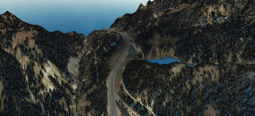
For example, in 2019 the WYDOT (Wyoming Dept. of Transportation) contracted with Woolpert to map three landslide areas along a 10-mile stretch of the Continental Divide in northwest Wyoming, close to Yellowstone National Park. Woolpert collected LiDAR at 50 ppsm and colorized the point cloud with imagery collected simultaneously with an integrated Leica RCD30 aerial camera. The final digital terrain models and triangulated irregular network models provided WYDOT with a baseline to determine the slide movement, volume, and rate at which the earth is moving over time. WYDOT performed an independent check and compared more than 120 individual point cloud elevations from field collected points. The average elevation difference of 3.6 cm exceeded the requested 5 cm vertical accuracy.
In Arkansas, LiDAR data has proved beneficial in supporting numerous business activities, including agriculture and precision farming, and has advanced flood-risk management, urban and regional planning, natural resources conservation, and critical mineral assessment. In recent years, Arkansas has coordinated with federal and local partners to improve the quality and availability of high-resolution elevation data for the state.
USGS has a contract to Woolpert to do LiDAR surveying in Arkansas, as well. Under this task order, Woolpert will collect 24,533 square miles of aerial data, including parts of the Ozark-St. Francis and Ouachita National forests, using a Leica TerrainMapper. Woolpert expects the LiDAR data to be acquired by fall 2024 and delivered in summer 2025.
Woolpert has supported 3DEP since its launch. The firm has collected data across multiple states, tested sensors for optimal acquisition, and provided training for state and local government officials. Most recently, Woolpert delivered 13,000 square miles of aerial LiDAR data collected across southwest Ohio and completed LiDAR data acquisition across Colorado and Oregon under additional task orders for the USGS.
The Leica TerrainMapper-2 is the latest linear-mode LiDAR airborne sensor providing the highest performance for regional mapping projects. The sensor system delivers outstanding accuracy, point density, and point distribution even in mountainous terrain. The system is designed to offer the maximum flexibility for all applications from narrow-swath corridors to high altitude applications over complex and changing environments.
As an early adopter of scanning technology, Woolpert has owned and operated every product in Leica Geosystems’ LiDAR series since the ALS40 was released in 2002. Woolpert purchased its first Leica TerrainMapper in early 2019 and has since acquired three more. Woolpert flew more than 10 USGS projects in various states in 2019 with the TerrainMapper. In states like Florida and Ohio, the large volume collection at high speeds was instrumental in completing mapping projects within one flying season, despite weather conditions.
Want to tweet about this article? Use hashtags #construction #sustainability #infrastructure #IoT #cloud