

Building information modeling, otherwise known as BIM, has been around now for several decades, although not always by that name. BIM is a process that generates and manages digital representations of physical and functional characteristics of places. Building information models span the whole concept-to-occupation or concept-to-use lifecycle of a structure or infrastructure component.
BIM models are computer files that may be in proprietary formats and contain proprietary data. However, the concept is that the data can be extracted, exchanged, or networked to support decision-making regarding a built asset. Open-source versions are becoming popular, especially with smaller companies, as they can be developed, modified, and integrated with other programs, all at a relatively low cost.
Regardless, BIM software is used to plan, design, construct, operate, and maintain buildings and diverse physical infrastructures, such as water, refuse, electricity, gas, communication utilities, roads, railways, bridges, ports, and tunnels. While the concept has been around since the 1970s, the term only became agreed upon in the early 2000s.
The BIM concept creates a virtual construction of a structure prior to its actual physical construction, to reduce uncertainty, improve safety, work out problems, and simulate and analyze potential impacts. Subcontractors from every trade can input critical information into the model before beginning construction, with opportunities to prefabricate or preassemble some systems off-site. Onsite waste can be minimized, and subassemblies can be delivered on a just-in-time basis rather than being stockpiled onsite.
Throughout the years, the level of demand for BIM has increased due to growing demand for green buildings and a variety of end uses such as civil infrastructure, oil and gas, industrial, utility, and others. It optimizes project performance and productivity and enhances the communication and coordination throughout the asset lifecycle management process.
Buying BIM
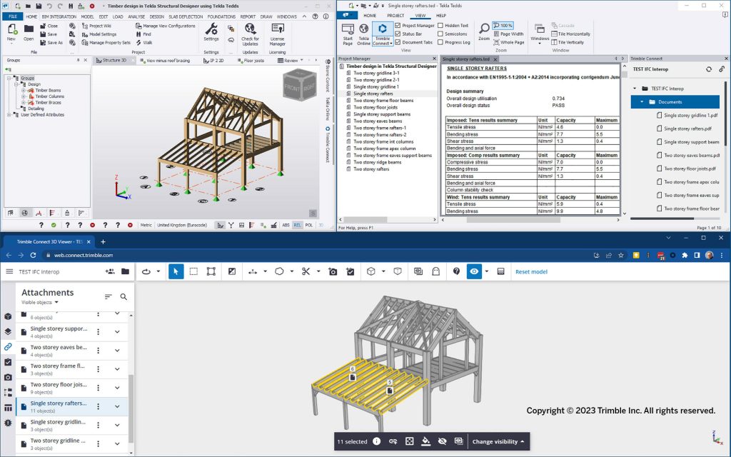
The BIM landscape is diverse and continually evolving. Major players have diversified product portfolios, strong geographical reach, and have made several strategic initiatives. Names as familiar as Autodesk, Trimble, and Bentley Systems provide various levels of BIM capabilities. Take Trimble’s Tekla Structures 2023, as an example. The latest version includes significant performance enhancements, enabling smoother information delivery on projects that are typically growing in both size and intricacy.
Performance is key to enabling multiple stakeholders to consult, use, and feed data into the models in connected workflows. Connected construction enables precision production, reducing rework through constructible design. It forms the basis for green construction strategies to optimize the use of resources, minimize waste, and enable full asset lifecycle maintenance.
With the use of open standards, Trimble’s Tekla products have an active partner community, developing, on the Tekla API (application programming interface), complementary applications and integrations for specialized industry sectors such as scaffolding design, industrial projects, and detailing for modular construction such as light metal framing.
A package deal, combining multiple levels of BIM and BIM-integrated software from the same company, can be a benefit, as well. Bentley, known for its infrastructure focus, offers such a collection called Civil WorkSuite. Civil WorkSuite gives civil engineers, planners, and designers the tools to design virtually any civil engineering project. It has tools to go from concept, to detail, to analysis, to visualization, to digital delivery including:
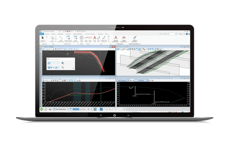
- OpenRoads Designer, an extremely versatile civil design application that is used for all types and sizes of civil projects around the world. The application addresses a wide variety of complex tasks such as interchange design, roundabout design, earthworks, surveying, sanitary and stormwater network design, subsurface utilities, and production of construction staking reports.
- OpenRoads ConceptStation is a road network conceptual design software. It allows the rapid creation of conceptual designs during the preliminary and planning stages of infrastructure projects.
- OpenBridge Designer leverages BrIM (bridge information modeling). With the latest bridge technology and capabilities, efficient modeling, designing, and production of project deliverables is possible in a dynamic, interactive, and parametrically enabled environment.
- OpenSite Designer is an application designed to address all aspects of site design, engineering, and land development. It also includes OpenSite SITEOPS, to quickly identify constraints, understand financial implications and project feasibility, and produce optimized solutions.
BIM for Safety
BIM and BIM-like digital models are handy for after construction modeling, as well. The KICT (Korea Institute of Civil Engineering and Building Technology) developed a digital model designed to identify dangerous roads where traffic accidents frequently occur while finding optimal measures to improve the safety of such roads, thereby minimizing the risk of traffic accidents.
A project, the Alignment Improvement Project for Dangerous National and Provincial Roads, aims to identify roads with a high risk of major traffic accidents and improve structural hazards found on them, preventing future traffic accidents, and enhancing their functionalities. Under this project, dangerous roads are selected based on a combination of factors including their geometry—how the roads curve and slope—the number of traffic accidents, the amount of traffic, regional characteristics, and investment expenditures. Among them, however, geometry is the most significant factor in the scoring system. Simply put, the geometric structure of roads, which determines their overall shape, is considered among the major causes of traffic accidents.
Against this backdrop, a research team developed a digital design of an optimized linear road model capable of identifying dangerous roads and minimizing the risk of traffic accidents on them. The developed digital design model employs big data to ensure that dangerous roads are identified and selected in an objective manner, unlike the existing method in which the selection process is conducted in a fragmented manner.
First, a traffic accident big data system was analyzed to identify and select dangerous roads, thereby determining the relationship between geometric factors and the occurrence of traffic accidents. In doing so, a total of 37,128 traffic accidents (especially fatal ones) that occurred on the country’s national and provincial roads from 2012 to 2020 were analyzed. Among them, 1,138 cases (accounting for 3%) were then selected where, for example, accidents occurred on curved roads or inclined roads. From the ones selected, 77 cases were further selected in which two or more traffic accidents occurred. These 77 traffic accident cases were considered to have occurred on dangerous roads, and an in-depth examination based on topographic-map and road-view analyses was further conducted on four cases among them.
The digital model was designed to quickly and easily provide multiple optimal alternatives to the selected road design in the form of a 3D model simply by inputting conditions and entering values for variables. In addition, it can also compare these alternatives in terms of the risk of traffic accidents and the volume of earthwork required, immediately determining whether each of these alternatives satisfies the design requirements. This process allows policymakers to determine which alternative will be the best solution to minimize the risk of traffic accidents.
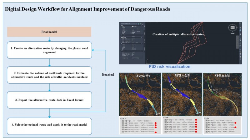
The distinctive advantage of the developed technology is that it integrates the entire process of decision-making, from the identification of dangerous roads to the generation of optimal alternatives using a digital model; that is, maximizing the efficiency of the process via digital transition.
BIM or CAD?
A question often raised among builders is, why do I need BIM when I already have 3D CAD (computer-aided design)? Autodesk answers: The difference between 3D CAD modeling and BIM is that, while both processes provide geometric expressions of buildings and infrastructure, the BIM process goes beyond geometry to capture the relationships, metadata, and behaviors intrinsic to real-world building components. Combined with technology of the BIM ecosystem, this data drives improved project outcomes in a way that 3D modeling cannot.
Both CAD and BIM processes are used to capture and communicate the design and construction intent of an AEC (architecture, engineering, and construction) project using a drawing representation, helping stakeholders understand what needs to be built, and how. BIM enables design and construction teams to leverage their technology investment to do much more. The BIM process supports creation and management of information across the lifecycle of an AEC project by federating all multi-disciplinary design and construction documentation into a common dataset. Since that data can be accessed in multiple representations, from 2D to 3D to tables, the information is far more accessible and connected than the disparate data sources associated with traditional CAD approaches.
What’s next? According to researchers at Technavio, current CAD is optimized for 3D imaging. BIM, on the other hand, can incorporate data for time and cost, creating a “5D” model. With the help of 5D building information modeling, an investor can obtain information on the deviation from the pre-determined project schedule and budget, using an in-house database with complete details regarding the cost and labor productivity rates. Also, with the help of 5D BIM, efficient preparation of cost schedules and realtime cost estimation for easy and quick comparison with the target cost will be done. Thus, this trend will drive the growth of the market during the coming years.
Technavio estimates the BIM software market size to grow at aCAGR of 19.61%between 2022 and 2027. The market size is forecast to increase by more than$6.6 billion. The growth of the market depends on several factors including the need for efficient solutions for managing large-scale construction projects. The primary goal is to automate processes in order to manage resources and maintain consistent follow-up while ensuring maximum outputs. Automated services improve connectivity, giving businesses the chance to respond quickly and efficiently to project-related inquiries.
The average annual spending of the U.S. construction industry is around $1 trillion. Building information modeling software market growth in the U.S. is anticipated to be driven by the expansion of both the residential and non-residential construction industries. By using building information modeling solutions, profitability can be increased by calculating conversion ratios and running reports to track the metrics detailed by customer demand.
Want to tweet about this article? Use hashtags #construction #sustainability #infrastructure