

There will soon be a new category of travelers, it seems. Dubbed “Catastrophe Tourists,” they will venture far and near to check off their list of “soon to be gone” locations. Wildfires consuming the area? Check. Ocean property now under water? Check. City sinking? Check. Ghost towns? Check. Parroting the cliched “Bucket List” of things to do and places to see before you die, the new tourist is instead seeking places that are dying and, unfortunately, the list is growing.
Climate change is the catch-all phrase for why cities and rural areas are experiencing repeated catastrophic weather, causing everything from wildfires to flooding, where such phenomena were rare in the past. And while the governments of most areas are struggling to find ways and funds to combat the destruction, other regions are bogged down in preliminary research to find answers. In rich Western countries, funds are available but convincing the population to spend them wisely is difficult.
In the U.S., the bipartisan Infrastructure Investment and Jobs Act of 2021 will fund more than $1 trillion and deliver $550 billion of new federal investments in America’s infrastructure over five years, touching everything from bridges and roads to the nation’s broadband, water, and energy systems. Experts say the money is sorely needed to ensure safe travel, as well as the efficient transport of goods and produce across the country. The nation’s infrastructure system earned a C- score from the American Society of Civil Engineers in 2021.
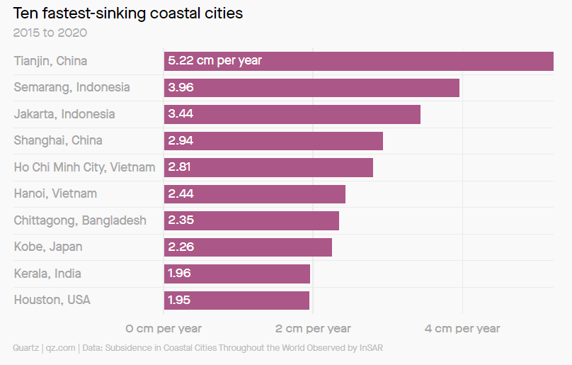
In many parts of the world, however, government agencies lack the funding necessary to make inroads in the destructive effects of climate change. This is particularly evident in coastal cities where the challenge of rising sea levels is augmented by sinking cities. The result is an increase in flooding during what would normally be considered average rainfall. Of course, average rainfall itself is increasing, seas are rising, and the literal weight of cities is causing them to slowly sink. In fact, some of the world’s major cities, not just fabled Venice, are sinking even faster than the sea levels around them are rising, according to research published in Geophysical Research Letters.
In a process called subsidence, land settles and compacts based on changes to materials below the earth’s surface. This subsidence has caused land in most of these cities to sink by several millimeters per year. Much of this is brought about by human activity ranging from building new subways to groundwater pumping. In the latter case, as water flows out, the land compacts, and the structures built on top fall closer to sea level.
According to the World Economic Forum, at least 33 cities are falling by more than one centimeter per year, five times the rate of sea-level rise, based on recent estimates. The fastest-sinking cities, concentrated in South and Southeast Asia, are forcing countries to adapt. For example, in part because the city is sinking, Indonesia is moving its capital from Jakarta, a megacity of 10.5 million, to a newly constructed city on the island of Borneo, 1,250 miles away.
More than Dutch Dams
If subsidence continues at its current rate, researchers warn, flood models that only account for sea-level rise will be insufficient to predict the intensity and speed with which worse floods will happen. Essentially, coastal cities are in for a watery future sooner than current models predict. Taking a cue from the Dutch, plans to floodproof cities in the future will need to involve floodwalls and other types of measures to keep water out but must also include regulation for the activities that sink cities further into the ground.
Some areas are prone to a natural amount of subsistence, but in many cities, human activities like groundwater pumping, oil and gas drilling, and rapid construction are accelerating it. Mexico City, built on the clay of ancient lake beds, has been sinking at a rate of nearly 50 centimeters per year after decades of draining the underground aquifers for drinking water.
Land subsidence seriously endangers the safety of people’s lives and property, especially in coastal cities, which are subject to natural disasters such as hurricanes, land loss, infrastructure collapse, floods, and storm surges under the combined effects of RSLR (relative sea level rise ) caused by global warming and land subsidence.
Of the top ten largest coastal cities at risk, only one is in the U.S.—Houston. But that doesn’t mean others are safe. Many cities are already seeing coastal flooding from a combination of subsidence and sea-level rise. Subsidence was fingered as a contributor to the Surfside, Florida condominium collapse in 2021, which killed 98 people. Off the coast of Virginia, an entire town on Tangier Island is sinking under the waves due to erosion and sea-level rise, forcing residents to evacuate.
And coastal cities, while the most vulnerable, are not the only locations where climate change has made an impact. A Northwestern University study has, for the first time, linked underground climate change to the shifting ground beneath inland urban areas.
As climate change causes the ground to heat up, it also causes it to deform. This phenomenon causes building foundations and the surrounding ground to move excessively (due to expansions and contractions) and even crack, which ultimately affects structures’ long-term operational performance and durability. Researchers also report that past building damage may have been caused by such rising temperatures and expect these issues to continue for years to come.
Although rising temperatures do pose a threat to infrastructure, the researchers also view it as a potential opportunity. By capturing the waste heat emitted underground from subterranean transportation systems, parking garages, and basement facilities, urban planners could mitigate the effects of underground climate change as well as reuse the heat as an untapped thermal energy resource.
The study was published in Communications Engineering and marks the first attempt to quantify ground deformations caused by subsurface heat islands and their effect on civil infrastructure. Northwestern’s Alessandro Rotta Loria, assistant professor of civil and environmental engineering at Northwestern’s McCormick School of Engineering, who led the study, said that “the ground is deforming as a result of temperature variations, and no existing civil structure or infrastructure is designed to withstand these variations. Although this phenomenon is not necessarily dangerous for people’s safety, it will affect the normal day-to-day operations of foundation systems and civil infrastructure at large.”
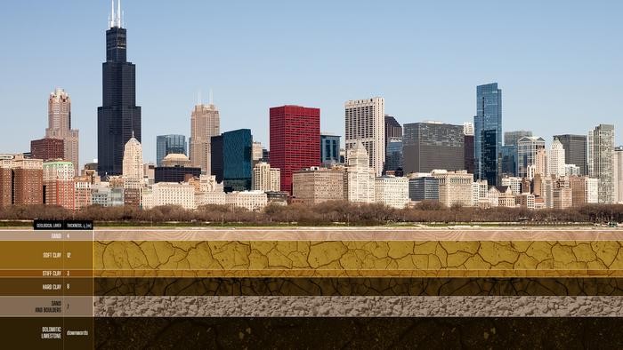
Chicago clay can contract when heated, like many other fine-grained soils. As a result of temperature increases underground, many foundations downtown are undergoing unwanted settlement, slowly but continuously. In other words, you don’t need to live in Venice to live in a city that is sinking—even if the causes for such phenomena are completely different.
What Is Underground Climate Change?
In many urban areas around the globe, heat continuously diffuses from buildings and underground transportation, causing the ground to warm at an excessive rate. Previous researchers have found that the shallow subsurface beneath cities warms by 0.1 to 2.5 degrees Celsius per decade. This phenomenon, known as “underground climate change” or “subsurface heat islands,” has been known to cause ecological issues (such as contaminated ground water) and health issues including asthma and heatstroke. But, until now, the effect of underground climate change on civil infrastructure has remained unstudied and little understood.
“If you think about basements, parking garages, tunnels, and trains, all of these facilities continuously emit heat,” Rotta Loria explained. “In general, cities are warmer than rural areas because construction materials periodically trap heat derived from human activity and solar radiation and then release it into the atmosphere. That process has been studied for decades. Now, we are looking at its subsurface counterpart, which is mostly driven by anthropogenic activity.”
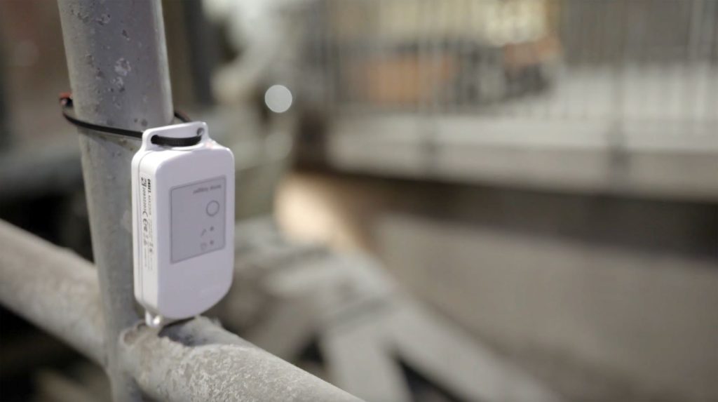
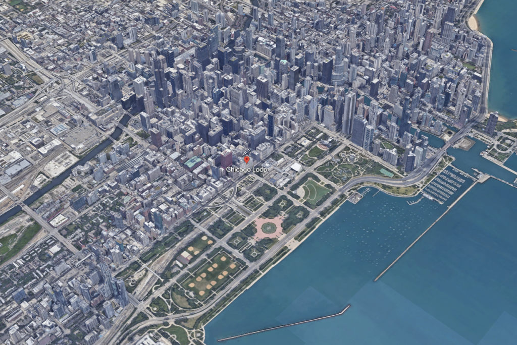
In recent years, Rotta Loria and his team installed a wireless network of more than 150 temperature sensors across the Chicago Loop—both above and below ground. This included placing sensors in the basements of buildings, subway tunnels, underground parking garages, and subsurface streets like Lower Wacker Drive. For comparison, the team also buried sensors in Grant Park, a greenspace located along Lake Michigan—away from buildings and underground transportation systems.
Data from the wireless sensing network indicated underground temperatures beneath the Loop are often 10 degrees Celsius warmer than temperatures beneath Grant Park. Air temperatures in underground structures can be up to 25 degrees Celsius higher compared to the undisturbed ground temperature. When the heat diffuses toward the ground, it puts significant stress on materials that expand and contract with changing temperatures.
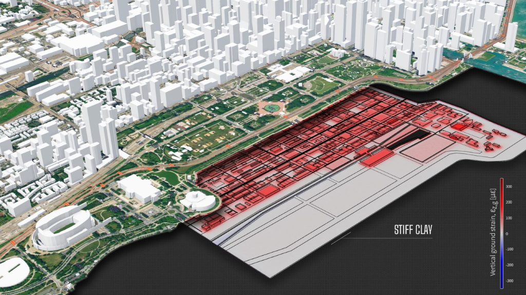
After collecting temperature data for three years, Rotta Loria built a 3D computer model to simulate how ground temperatures evolved from 1951 (the year Chicago completed its subway tunnels) to today. He found values consistent to those measured in the field and used the simulation to predict how temperatures will evolve until the year 2051. He also modeled how ground deforms in response to increasing temperatures. Whereas some materials (soft and stiff clay) contract when heated, other materials (hard clay, sand, and limestone) expand.
According to the simulations, warmer temperatures can cause the ground to swell and expand upward by as much as 12 millimeters. They also can cause the ground to contract and sink downward—beneath the weight of a building—by as much as 8 millimeters. Although this seems subtle and is imperceptible to humans, the variation is more than many building components and foundation systems can handle without compromising their operational requirements.
“Based on our computer simulations, we have shown that ground deformations can be so severe that they lead to problems for the performance of civil infrastructure,” Rotta Loria said. “It’s not like a building will suddenly collapse—things are sinking very slowly. The consequences for serviceability of structures and infrastructures can be very bad, but it takes a long time to see them. It’s very likely that underground climate change has already caused cracks and excessive foundation settlements that we didn’t associate with this phenomenon because we weren’t aware of it.”
The Old, the New(er)
Because urban planners and architects designed most modern buildings before underground climate change emerged, they did not design structures to tolerate the temperature variations we experience today. Still, modern buildings will fare better than structures from earlier time periods, such as the Middle Ages.
“In the United States, the buildings are all relatively new,” Rotta Loria said. “European cities with very old buildings will be more susceptible to subsurface climate change. Buildings made of stone and bricks that resort to past design and construction practices are generally in a very delicate equilibrium with the perturbations associated with the current operations of cities. The thermal perturbations linked to subsurface heat islands can have detrimental impacts for such constructions.”
Future planning strategies should integrate geothermal technologies to harvest waste heat and deliver it to buildings for space heating. Planners also can install thermal insulation on new and existing buildings to minimize the amount of heat that enters the ground.
Another project, led by the U.S. Dept. of Energy’s Urban Integrated Field Laboratory, will help historically under-resourced, disinvested communities that are more vulnerable to the effects of climate change. Scientists from Argonne National Laboratory and CSU (Chicago State University) have deployed a set of scientific instruments called CROCUS (Community Research on Climate and Urban Science) in Chicago. CROCUS is a five-year, $25 million program carried out by a team of 17 organizations, and funded by DOE’s Office of Science, Office of Biological and Environmental Research.
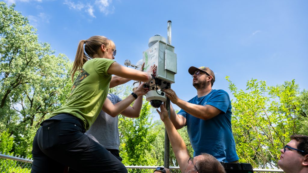
This is the second CROCUS deployment—the first of which occurred in May 2023 at Northeastern Illinois University. CSU serves as the southern end of the project’s node network, with more than 20 sensor arrays to be deployed throughout the next five years across the city to gather more data on Chicago’s changing climate.
Instrumentation was placed on the rooftop and two ground locations at CSU. The equipment will measure air quality, weather conditions, rain, and soil conditions. The nearby neighborhood of Chatham experiences some of the most extreme flooding in Chicago and the heavier, more frequent rains associated with climate change will only make matters worse. The new sensors will help researchers understand how much water different surfaces, landscapes, and vegetation can absorb or channel away, important information for making communities like Chatham climate resilient.
CROCUS’s team of researchers are looking for data on how weather patterns will change over the next 10 to 50 years as well as more detailed data on what’s happening now, on a neighborhood-by-neighborhood basis. Individual neighborhoods and even city blocks have their own microclimates, and these conditions are shaped by everything from the number of trees and greenspaces in the area to the height and color of the rooftops to the historical use of the land on which the neighborhood was built.
Chicago’s microclimates interact with each other in a complex quilt, which in turn interacts with the climates of the surrounding suburbs, farmland, and Lake Michigan. Sensors like the ones deployed will give researchers greater insight into how those microclimates work. The data collected will allow researchers to create long-term models to better predict how climate change could impact Chicago and other urban areas across the Great Lakes region.
Researchers consolidated results from more than 500 studies focused on urbanization and its impacts on weather and climate. The review encompasses urban heat islands (for canopy, surface, boundary-layer, and other areas), heat waves, atmospheric moisture, wind fields, boundary-layer structure, dispersion of air pollutants, cloud formation, precipitation, and storms. Timely data on heat islands, flooding, and extreme weather will help communities better understand issues that need to be addressed right now to protect their families, neighbors, homes, and businesses.
Want to tweet about this article? Use hashtags #construction #sustainability #infrastructure