California is noted for many things, not all of them positive. Among the negative aspects of living in the state is the chance of wildfires, floods, earthquakes, and landslides. Worse, a combination of two or even three of those natural disasters has grown in potential. According to the AGU (American Geophysical Union), Southern California can now expect to see post-wildfire landslides occurring almost every year, with major events expected roughly every ten years.
Californians are now facing a double whammy of increased wildfire and landslide risk caused by climate change-induced shifts in the state’s wet and dry seasons, according to researchers who mapped landslide vulnerability in the southern half of the state. Wildfires make the landscape more susceptible to landslides when rainstorms pass through, as the water liquefies unstable, dry soil and burned vegetation. Geologists routinely conduct landslide hazard assessments after wildfires occur, but there is often not enough time between a fire and a rainstorm to implement an effective emergency response plan.

In a study, AGU researchers combined historical fire, rainfall, and landslide data with computer simulations to forecast where post-wildfire landslides are likely to occur in Southern California, how big those landslides might be, and how often they can be expected to happen. Their goal was to map which regions of the state are most vulnerable to landslides before they happen, in a manner like how geologists map earthquake hazards.
The results show small landslides can now be expected to occur almost every year in Southern California. Major landslides capable of damaging 40 or more structures can be expected every 10-13 years—about as frequently as magnitude 6.7 earthquakes occur in California. The results also suggest more intense rainfall, which is likely to happen in the coming decades, could make landslides much more frequent.
Worldwide, urban areas may be at greater risk for precipitation-triggered landslides than rural areas. Landslides cause thousands of deaths and billions of dollars of damage annually. With more than half of the world’s population in urban areas, and both urbanization and precipitation extremes expected to increase in the future, understanding how urban landscapes are affected by precipitation-triggered landslides is a pressing need.
A study at AGU used a large database of precipitation-triggered landslides across the Pacific coast of the U.S. and isolated the influence of precipitation changes using a specific type of computer model. When the researchers controlled for other factors, like slope steepness, rock type, and wildfire, they found urban landslide hazard was up to 10 times more sensitive to variations in precipitation than in rural areas. That means the same increase in rainfall in rural and urban areas could be 10 times more likely to cause a landslide in a city.
And while California wildfires and earthquakes seem common, the state isn’t the only place sensitive to the effects of shifting land and climate change. The AGU Landslide Blog reports in mid-April 2023, the State Geologist of Utah, Bill Keach, warned of an increase in landslides in Utah this year. A few days later, on April 22, his warning came to pass when a landslide occurred in the town of Draper, destroying two houses. The two destroyed houses were completed in December 2021 by a developer. Problems emerged in early 2022 with the development of cracks in the structure and in the surrounding ground. Attempts were made to stabilize the properties, but in October 2022 the owners were forced to vacate the buildings.

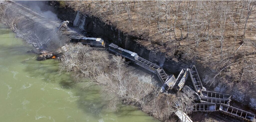
On March 8, 2023 a rockslide triggered the derailment of a coal train near Sandstone, West Virginia. The rockslide that triggered the derailment was small but sufficient to derail all four locomotives and nine coal cars, according to a statement by the train operator, CSX. The front locomotive, which was transporting three members of the train crew, caught fire. All three people escaped, although they were injured.
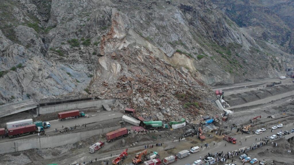
On 18 April 2023, a large rockslide occurred at Torkham in Pakistan, very close to the border with Afghanistan. The landslide, which occurred in the early hours of the morning, struck a line of trucks waiting to cross the border. It is thought about 20 trucks were buried in the accident.
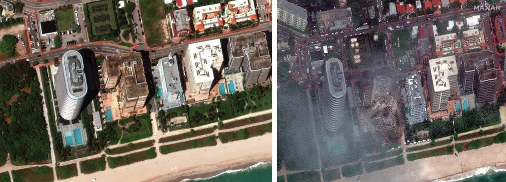
Unfortunately, the land isn’t the only place catastrophic collapses happen. On Thursday, June 24, 2021, at approximately 1:20 a.m., first responders were dispatched to a partial building collapse at the 13-story Champlain Towers South Condominium near Miami, Florida. The destruction of the building resulted in the deaths of more than 100 people. Nearby towers were evacuated, state and city inspectors worked day and night to check other buildings and ease the fears of residents.

On April 18, 2023, a New York City parking garage collapsed. The building, nearly 100 years old, apparently had too many vehicles on the roof which contributed to the structural failure. The manager of the parking garage was killed in the collapse when the Ann Street building in lower Manhattan caved in just after 4 p.m.
On April 26, 2023, a new construction in Madison County, Kentucky for the Madison County God’s Outreach Food Distribution Center Project, partially collapsed sending four employees to the hospital. A call came around 9:43 a.m. The structure in Richmond had partially collapsed. Four subcontracted employees were injured and transported for medical care.
What can be done to provide critical predictive alerts for building and terrain collapse? One suggestion, backed by research and testing in Korea, is to deploy special sensors in areas prone to shifting. The KICT (Korea Institute of Civil Engineering and Building Technology) developed a smart sensor that detects signs of ground or structure collapses and feeds that information to a realtime remote monitoring system.
The development of the sensor and system began with a search for a method of instant sensing of the collapse of slopes or buildings caused by ground movement. This led to the development of a smart sensor that turns on a LED warning light upon detecting ground movement.
While earthquake monitoring sensors have been used for decades, existing systems that measure the ground movement are not widely used because they are intended for use by experts and are costly and difficult to use. KICT, a thermal camera and image sensor venture company emtake, and KICT’s spin-off JAK Co., Ltd, jointly developed a highly efficient entry-level sensor and systems that can be deployed for continuous monitoring of ground movement in high-risk areas.
The sensors can be easily installed one to two meters apart in areas susceptible to collapses. They detect changes in slope as subtle as 0.03 Celsius. Upon sensing signs of a collapse, they immediately turn on an LED light to give a warning. The sensors have highly efficient optical transmitting lens technology, so the LED alert is visible to the naked eye even at a distance of 100 meters at day or night.
When the warning light turns on, those monitoring in the situation room can remotely ascertain what is happening in the affected area in realtime. This helps them take additional measures such as sharing the developments of the collapse with the appropriate authorities.
The sensors are much easier to install than existing sensors and their cost of installation and operation are more than 50% lower. They can run almost a year without battery replacement thanks to their ultra-low power consumption. The sensors are expected to be widely used in areas with distinct seasonal variations because they endure and function well even at extreme temperatures of −30 Celsius to 80 Celsius.
To prevent false alarms, an algorithm in the sensors analyzes and evaluates the risk based on the conditions of the monitored locations. The sensors can be used at sites of construction, public works, tunneling work, dilapidated buildings, and historical properties, as well as mines, underground structures, areas susceptible to landslides, and so forth.
The sensors were installed on a pilot basis in lava tubes, cut slopes alongside highways, slopes in mountainous areas, and alongside the high-speed railways in the Seoul metropolitan area. Although no deployment of sensors can cover every contingent, engineering analysis can pinpoint logical areas for monitoring. It is expected sensors such as those being tested in Korea will be installed at more and more sites of major construction projects as well as building demolitions.
Want to tweet about this article? Use hashtags #construction #infrastructure #IoT #cloud #edge


